Hurricane Bertha
July 4-15, 1996
Hurricane Bertha made landfall as a category 2 storm on July 12,
1996 near Wilmington, North Carolina. Bertha's path up the U.S. east coast
impacted states from South Carolina to Maine. On its passage north
through the U.S. Virgin Islands, an estimated 2500 homes were
damaged. The estimate of homes damaged on the U.S. mainland was
5000 and the cost of the damage was estimated at $270 million.
Bertha was responsible for eight deaths. Close to three-quarters
of a million people were evacuated from coastal areas lying within
Bertha's predicted strike zone.
Ocean Turbidity
Hurricane Bertha evidently increased the coastal water turbidity
from South Carolina to Virginia as seen in the after image.
The largest changes are concentrated in the northern areas of
Long and Onslow bays with very large changes associated with the
capes including Cape Hatteras, North Carolina to the north. The large turbidity
plumes emanating from the cape areas could be associated with
resuspended sediments from shallow shoals as well as sediments
generated from beach erosion due to the severe storm conditions.
In this respect the turbidity difference image for Bertha
is very similar to that of hurricane Fran a few weeks later although
the overall effect of Fran was greater.
| Before | After | Difference (after minus before) |
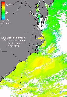
Sea Surface Temperature
The SST difference image depicts an overall cooling in
most areas. However a region of warming is seen in the vicinity
of Cape Hatteras, North Carolina perhaps due to a onshore displacement
of warm Gulf Stream waters.
| Before | After | Difference (after minus before) |
For scientists more time series Satellite Images in GEOTIFF Format
are available